maanantai 29. kesäkuuta 2015

Climbing Maria Lloco

Maria Lloco is a 5552 meters 18,200 ft high mountain just west of Huayna Potosi. On June 28th I left at 3.48am because I woke up early. I drove to Milluni which is close to Huayna Potosi base camp, and then onto a smaller road that went up on the south side of Huayna. I stopped at 4830 meters 15,850ft and started walking at 5.55am. It was still dark and I used my headlight but the batteries died in a couple of minutes. Full moon was only a few days away so it was not too dark without a light and at 6.30 it there was some light. That road goes to Tuni and Condoriri reaching over 5000 meters, and there is another road that goes closer to the west side of Huayna Potosi and Maria Lloco but I've read it's a private road and they charge 50 bolivianos 7 dollars to open the gate. Also I had believed the road I would be driving to be really bad, which the police in Milluni also pointed out, but it was not that bad. It was quite good actually, but still I walked from the other side and had to climb up to 5245 meters and then descent a difficult rocky slope to 4750 meters again before climbing the 5552 meter high Maria Lloco. I wanted to take an intermediate route. While on the lower slopes, it looked like there was a snow slope and then a couloir leading relatively close to the summit, so I took that route which was nice and quite steep but not too steep.
When I got to the top of it and to a ridge, the summit still seemed to be far away. The ridge and the other side of the mountain were free of snow at that altitude. It was loose rock. It didn't look like something I wanted to climb so I decided to climb below the ridge on the snowy side traversing towards the summit while slowly gaining elevation among some rocks. But as soon as I left the couloir the snow turned loose sugar snow and the slope was steep. At times the snow was thigh deep and climbing was very slow. Not that much fun but eventually I reached a short snow slope leading up to a big pile of loose rock that was the summit. I took my climbing boots off for the summit. The views of the Huayna Potosi west face and the cordillera real were impressive.
  I had a feeling that going down was going to be bad. After going down the highest, rocky part, I put on my boots and crampons just to descent less than 10 minutes on snow but then I chose to take the rocky side to go down. I think I should have taken the snowy side but another route there. Going down a steep mountain side made up of loose rock is a nightmare and takes a very long time.
  I went back down to 4730 meters and on the way back to my car I took a route that gently rose up to 5100 meters on very nice terrain for walking and then on the other side the road at 5030 meters. There the road was almost flat and very good. It was 6.20 when I was back at the car so the trip took 12 hours 25 minutes car to car. That's a long long time, much longer than my typical climbs.

Maria Lloco in the morning:


Huayna Potosi's 1000m high west face from the summit of Maria Lloco:


Funny natural lines of sand and small stones.

I think I'm done with mountains for now. It's been a fun "season" of climbing and each trip has been a huge experience. My favorite was Charquini. Mururata was a good day too.

perjantai 26. kesäkuuta 2015

Acotango Climb

I drove to Sajama national park (an area that has 4 mountains over 6000 meters high) on Thursday June 18th, and from the very small Sajama village to the base camp of Parinacota and Pomerape. Or I thought it was the base camp, but later concluded it was in the next valley. I wanted to walk to the high camp and climb both mountains the next day, but after a while my backpack's left shoulder strap ripped off. Not a very good backpack. And I was carrying a lot of water. It was not too late, so I decided to make a really quick try on Parinacota. But I didn't want to leave any of my stuff outside low on the mountain because this is Bolivia, so I returned to the car and left most of my equipment in the car and took off again with smaller backpack and everything needed for a one-day attempt. By now it was almost 3pm. I climbed up until 5300 meters and estimated I could have made it to the summit just before the sun went down (of course this was a really optimistic estimate) but then thought it was better to return because I didn't feel like having an adventure in the darkness coming down. I returned to the car again.
 I thought about my options: the first one was camping where the car was at 4800 meters. It was windy and these mountains are volcanoes, and the soil is a very soft mix of sand and ash. It was quite dusty in the wind. I didn't like the idea of staying the night there because I have always tried to avoid camping alone at low elevations since I've read stories about thefts in all "major" mountain base camp sites in Bolivia. Here I hadn't seen anyone after the Sajama village that was one hour's very slow drive away, but there were a couple of houses along the way,and in this country there are usually people outside almost everywhere, except at really high elevations at 5000 meters and over. I still think it's extremely unlikely it would happen, but I just didn't want to take the risk of someone coming to wake me up in the night with a knife. And if you can rob money, why not take the car too? To be realistic, if something disappears from your remote camp in Bolivia I think they are kids stealing the stuff, not hard core criminals. Sure, almost all Bolivians I know are good people, but still a lot of people here wouldn't hesitate to steal if they have the opportunity. And many are looking for an opportunity to steal.
My car isn't very big so sleeping in it would not have been even remotely comfortable. In 2009 I made a trip to Sweden and Denmark, sleeping 4 nights pretty well in my car but it was a longer kind of car. It was a nice trip. I had a road bike with me and did rides and runs in both countries.
I made the decision to return to the village. Maybe I should have just climbed the mountain and not return and maybe I should have just camped outside, but I didn't. Not now. I didn't have the right feeling. I got lost two times, but thanks to my car being a 4x4 vehicle, I was able to make u- turns in the soft sand and not get stuck. This trip was the first time I ever had to use the 4x4. I took a hostal room for about 5$. Very cheap, but in fact the room was quite good for Bolivia.

The next morning I headed for the mountain called Acotango which is a 6052 meters or 19,855ft high mountain. As I was leaving the village I saw a tourist outside, obviously waiting for some sort of transport out of the village to the paved "highway" or the next town. In the countryside where people don't have cars and where there is very little public transportation, there are always people on the side of the road wanting you to pick them up. Driving close to Illimani a few weeks back I eventually gave up and decided to give an old man a lift since I was already driving super slow, but it turned out he was just curious and wanted to talk to me. So in general, there's no way I'm going to pick up a Bolivian stranger while driving, but a German tourist, of course. There are hot springs and geysers close to Sajama, the area is pretty, and the climbing is good so the Sajama area is a (very) minor tourist spot. Plus it's less than 3 hours from the Chilean coast and beach towns. We drove 30 minutes to the border town Tambo Quemado, talking in Spanish. From there I took a smaller road leading to Acotango. There is a good mining road going up the mountain. Up the road I saw a tractor working on the road and 3 men, and higher up a truck was coming down. I took the first spot where I could park the car because I couldn't see if there was enough room to pass. I was already at over 5300 meters! Definitely the highest I have ever driven. Also I knew the climb was not going to be very hard, but most of all, I didn't want to get on the miners' bad side. In this country they have a really bad reputation for being troublemakers, making protests and blocking the most important highways, and throwing dynamite while doing that. In Sajama I was told they would charge 100 bolivianos or 14 dollars for climbing the mountain.
The 3 men in the truck stopped to talk to me. Nice people! When I passed the tractor and the other 3 men, they wanted to talk as well. Nice people!
I walked up the road. Not because it seemed to go toward the summit, it didn't, but because I wanted to see how high it went and how good it was near the end. The snow line was maybe at 5350 meters but I have seen from pictures that later in the year there might not be snow at all. The road however was mostly free of snow and ice up until 5600 meters! Crazy. I was still quite far from the summit distance- wise. I had left the car really late by mountaineering standards at 11.20 a.m but it was ok because the mountain doesn't have glaciers, just snow. The snow was still ok the whole day, not too soft. I took a route mostly following a ridge leading to the summit. A nice route but the shortest routes would have been steeper and more exciting. No matter how short the actual climb, moving at 6000 meters is always slow and tiring and anyways it will take hours. Here is the final part of the climb:
Then the summit. My gps said 6073 meters which I have also seen online I think, but Wikipedia says 6052 meters. I continued and went down the ridge to the other side and then down a steep slope.
Overall it was a nice worry free climb with good views. Felt really safe, didn't see anything that could be dangerous. It was not windy now. Third 6000 meter mountain I have climbed during this year's mountain campaign.
I was home in La Paz at 10.30 that night. I need to go back to that area for more mountains but I'm not sure if I'll have the chance to climb more soon or if I'll have to do other things.

sunnuntai 14. kesäkuuta 2015

Climbing Mururata

Among all the people who live in and around La Paz, Mururata is the second most well-known mountain after its close neighbor Illimani. It is 5880 meters 19,300 ft high. From La Paz it is therefore the second most visible snowy mountain. Looking at it from La Paz the glacier looks very flat, but from other angles it looks less flat but still gentle.
  Saturday, June 13th I left at 5.16 am and it took just over two hours to get to where I started walking. There is a very small road that goes very close to the glacier (but not in the same valley) to over 4800 meters of altitude, but there was a 200 meter section of the road that was just really really bad, so after that I parked at the first area where it was possible. One of the things I want to avoid the most while doing these trips is getting stuck while driving a mountain road. Of course, veering off the road and tumbling hundreds of meters down would be worse, but a lot less likely than getting stuck. I think all the small roads here have parts where you can't drive where you'd normally drive, because the tire tracks can be up to 30cm deep. So, you drive on the right edge or the left edge of the road to avoid your tires falling into the deep tire tracks. When possible, it's better to take the non- cliff side.
   I was at 4230 meters of altitude and far from the glacier but I thought it was better to walk. It was 7.30 when I left the car. The walk was really easy at first and there was a path, then there were a couple of times when I had to climb a little bit of rock but it was easy too because the rocks had like natural steps. I tried and was able to move very fast. Including a couple of stops it took 2 hours 13 minutes to reach the glacier which started at 5015 meters. Entering the glacier I had walked 5,8 kilometers.

I was glad to find out that the glacier was nowhere near as easy- angled as it looks like from afar. It was not very steep, but I liked it. This is still the first part of the climb, and the highest summit is not in the picture.
Some foreigners ski down Mururata, and it indeed would be super nice for skiing especially in the right conditions. Now the snow was hard, but the surface was quite rough. Still would have been ok for skiing. I didn't see anybody else on the mountain. From 5600 meters I was able to see the distant highest summit, but I turned left a little bit because I wanted to see the other (north to east) side of the mountain that is very steep. The other side could be totally unclimbed since there is no information or mentions on anyone climbing it online or in a guide book. It would be quite difficult to get to the base of the mountain on that side. I took some of the greatest pictures I have ever taken and enjoyed the magnificent views of La Paz, Altiplano, Chacaltaya, Huayna Potosi, Tiquimani, the ocean of clouds over Los Yungas, Illimani, and all other mountains. I could even see for the first time the mountain range called Cordillera Quimsa Cruz to the southeast of Illimani. The highest peak there is 5800 meters high which is pretty high. That area is climbed by very few. It was also interesting to see the other side of Illimani.


The sun was quite warm and high on the mountain and a lot of times the snow gave up just a little bit under my steps. The highest point of the mountain is the right summit.
I was on the summit at 12.00 o'clock after 11,2 kilometers on foot in 4.01 hours moving out of 4 hours 30 minutes since I left the car. Elevation gain was 1650 meters, over a mile. I spent 11 minutes on the summit and then began going down. Where the snow was good, I was able to jog and run down the slopes. It took only 1 hour 7 minutes in total to get out of the glacier, and after that I ran some parts too, but while trying to find an easier route, it turned out a lot harder than the route I had ascended- a very typical result. So, from the glacier it took 1 hour 52 minutes to reach the car when I had hoped for 1 hour. All in all it was a 22,1 kilometers or 13,75 miles long trip car to car in 7 hours 40 minutes including all the stops and everything.

perjantai 12. kesäkuuta 2015

Climbing Charquini

Wednesday, June 10th I left at 4.19 am and drove 1 hour 40 minutes to get close to the base of Charquini. It is a 5389 meters high mountain just opposite Huayna Potosi, and I was pretty close to HP basecamp. I chose to climb from the south because the north side looked a little bit too easy based on internet research and Google Earth.
From where I parked it took only 45 minutes to walk to the bottom of the glacier, and then 25 minutes to walk the not-very-steep first slope. I'm glad I didn't take the steep slope that's on the right in the picture because on the other, sunny side there is almost no snow there.

Then, I had the choice to go left and up, or go right and down a little bit and take the steep slope. Maybe there would have been enough snow all the way up on the left hand route, but the option on the right looked like more fun. The low area in the middle of this picture would have been perfect for camping.
The morning light made the views look really nice as I was heading 70 vertical meters down.
The steep face had a crack (called bergschrund) that seemed to extend laterally from one side of the slope all the way to the other. It was about 1 or 1,5 meters wide and parts of it were covered but still obvious. However the snow covering the crack was soft so it was not possible to walk over, and above the crack there was some soft snow too.


The slope is about 100 meters wide and I walked below the bergschrund covering it almost two times, until I eventually found out that at the very left side of the slope the crack was very narrow and easy to cross. It was quite steep climbing. About 55 degrees for 100 vertical meters and I passed an interesting ice cliff on the way up.
On the top there was a little flat area 10m. wide under a rock wall, which then turned into a ridge leading to a subpeak. I think the subpeak was 5350 meters high. I took in the views, took pictures, and then headed down the other side a little bit. It really surprised me how large the glacier on the other side was. The whole mountain and the climb were a real positive surprise. The day was sunny, not cold, and there was no wind. The views of Huayna Potosi, Tiquimani, and other mountains were great.
So I went down and then back up to the highest summit that's 5389m. Close to the summit there was almost as much rock as snow but the angle was easy. It was 9.46 am when I started going back down. I didn't want to take the same way back because going down the steep slope would have been slow and I also wanted to make a full circle and see all of the other side too. I ran down the easy clacier and then continued fast on a good path. Unlike many other mountains, this one was easy to descent. It was not too rocky or slippery. After a while I reached an aqueduct that was almost flat and easy to follow almost until a lake between Charquini and Huayna Potosi, where there is a dirt road. I jogged part of the way back to my car, and after 14,6km or 9miles in total, I started the drive back to La Paz at 12.

tiistai 2. kesäkuuta 2015

Illimani Climb

I had wanted to climb Illimani since 2012. It is the most well known mountain in Bolivia because it dominates the view from La Paz, although not visible from all parts of the city. It's very much a symbol of La Paz. That's why for me it was the most important mountain to climb now that I'm back in Bolivia. It's the second highest in the country. One of the peaks, 6130m/20,122ft high was first climbed in 1877 and was the highest climb in the world by that time. The climbers were a Bolivian, a French, and a Peruvian. It's crazy to try to think about what was the world like in 1877... The highest peak of Illimani was first climbed in 1898 by a British and two Swiss climbers, and the second highest 6403m peak was reached by two Germans in May 1950. So the history of climbing on Illimani goes way back. 8000 meters in the Himalayas (Annapurna) was first reached in June 1950.

 In 2011 when I spent 8 months in Bolivia I was a little bit curious about climbing mountains, but I didn't like the idea of spending several days in the cold, didn't want to pay an agency, didn't have my own transportation, and didn't have any experience, so I didn't do any climbing. Normally it takes 4 days to climb Illimani with a guide arranged by an agency and I think it costs between 300 and 500$. I paid around 15$ for gas and already had the equipment needed.
   I also had put off going to Illimani many times during the past couple of months for various reasons, but on Saturday evening I finally decided to go the next day, even though mountain forecast website said it would be partly cloudy and snowing a little bit on Sunday and Monday. For the past 4 months I've been working 20 hours a week with pretty good flexibility, so I've been able to choose when to climb.

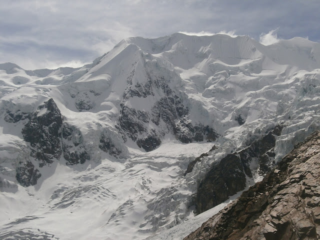
This is how the mountain looks like from the direction of La Paz. The right hand side peak is the highest, 6439m/21,122ft

So, on Sunday I left before 7am and it took almost 3.5 hours to get to the group of houses called Pinaya. It looks like the mountain is really close to La Paz, but it's about 38km away and by roads the distance to Pinaya is about 80km. Altitude at Pinaya is 3870 meters or 12,700ft. I started walking and asked a man with three sons which would be the best path to the mountain, but I don't think I found the path he talked about so it took a little longer. There were plenty of people out on the fields with or without animals, so it was a different experience than in other mountains because they were watching. Even when I was quite high just at the bottom of the mountain face, there was a boy watching his animals, and even higher a girl with horses. Quite nice views to work. High above I saw 3 climbers on a path, going down. The route I had taken was rocky and difficult. When I joined the path I was hoping to encounter climbers going down or up, but it turned out there was nobody else on the mountain. I was thinking of the reasons why I climb mountains; I thought it's because I can see them and wonder what's it like to climb and experience them. I used to look at some mountains, and after I climbed them they became real. The views are also important, and taking photos too.
 The route to the high camp is a narrow rocky ridge that is quite steep too and not easy to walk. At 6.20 it was getting dark and I took a spot just below where the high camp "officially" is, because it had like a little wall to protect the spot from the wind at 5410m. There was not much space, and the drop was steep and high on both sides. I put on all my clothes, ate one bread and got inside my sleeping bag at 7 p.m. The top of the mountain had some clouds, but other than that the sky was clear and the moon was full. Full moon was one of the reasons I wanted to do the climb now. It would have been spooky to be alone on the mountain ridge had it been foggy or clouds down to the camp.
I was really afraid of getting cold in the night but I was warm the whole time, sleeping a little bit on and off
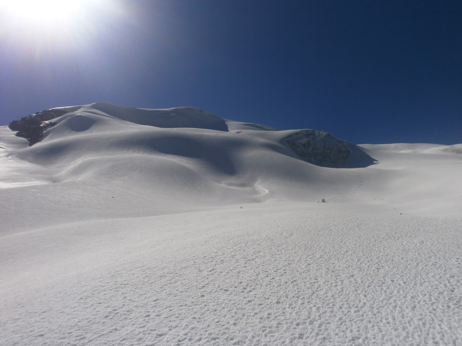
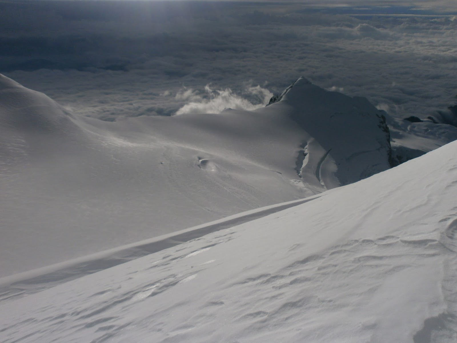
until about 3.15 am when I got up and ready, took my smaller backpack and at 3.31 headed 60 vertical meters up the rocky ridge until a flat area where the snow begins, and put on my boots and crampons. On both side of the ridge there is snow and glaciation down to maybe 5000 meters. The moonlight was so bright that I barely needed the headlight. Some sections of the climb were quite steep, up to around 45 degrees for a while, and other parts were flat. Only one little wall was a little bit difficult to get over because it was soft snow. For some reason I hadn't really been able to eat anything since Sunday afternoon, had zero appetite, and soon didn't have anything to drink. That's probably why I slowed down a lot after about 2 hours. It also got cloudy and really dark until the sun came out on the other side of the mountain, and it was really windy higher up. At 6250 meters I wanted to go down because I was so tired. I sat down on top of my backpack and wanted to sleep but after 5 minutes got up thinking that it's now or never.
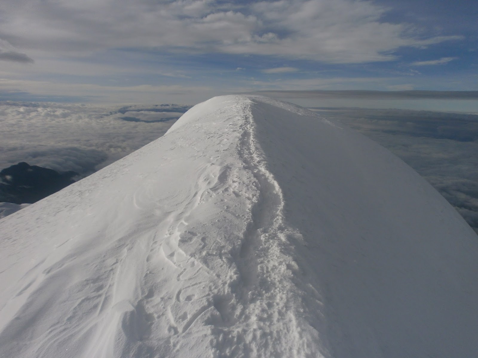
I literally had to rest after every 3 steps to get to the top but it was awesome to get up and see the summit ridge that leads to the "real" summit which didn't seem to be any higher than the first summit. I was at the top at 8.15. From the camp it had taken about 4 hours 12 minutes to get to the summit excluding breaks. So in total I rested over 30 minutes on the way.


Going down was very very slow. Sometimes I have been able to almost run down a mountain, but now I had no energy and it took over 2 hours to get back to the camp, and then came the hardest part of the whole trip: going down the rocky ridge with a huge and heavy backpack. Like on many mountains in Bolivia, it's slabs of rock of all sizes on top of each other so it's very slippery. And I got off the path and down a steep section and saw that there was no path anymore. I couldn't go up, and had to do a terrible traverse to my left to find the path again. All in all it took another 5 hours from camp to the little village. In the first 1 hour 30 minutes of the drive back to La Paz I only saw one vehicle on the road, which was a motorbike. There were people walking on the road, villages and houses here and there, and a few cars parked on the side of the road, but no traffic.