Among all the people who live in and around La Paz, Mururata is the second most well-known mountain after its close neighbor Illimani. It is 5880 meters 19,300 ft high. From La Paz it is therefore the second most visible snowy mountain. Looking at it from La Paz the glacier looks very flat, but from other angles it looks less flat but still gentle.
Saturday, June 13th I left at 5.16 am and it took just over two hours to get to where I started walking. There is a very small road that goes very close to the glacier (but not in the same valley) to over 4800 meters of altitude, but there was a 200 meter section of the road that was just really really bad, so after that I parked at the first area where it was possible. One of the things I want to avoid the most while doing these trips is getting stuck while driving a mountain road. Of course, veering off the road and tumbling hundreds of meters down would be worse, but a lot less likely than getting stuck. I think all the small roads here have parts where you can't drive where you'd normally drive, because the tire tracks can be up to 30cm deep. So, you drive on the right edge or the left edge of the road to avoid your tires falling into the deep tire tracks. When possible, it's better to take the non- cliff side.
I was at 4230 meters of altitude and far from the glacier but I thought it was better to walk. It was 7.30 when I left the car. The walk was really easy at first and there was a path, then there were a couple of times when I had to climb a little bit of rock but it was easy too because the rocks had like natural steps. I tried and was able to move very fast. Including a couple of stops it took 2 hours 13 minutes to reach the glacier which started at 5015 meters. Entering the glacier I had walked 5,8 kilometers.
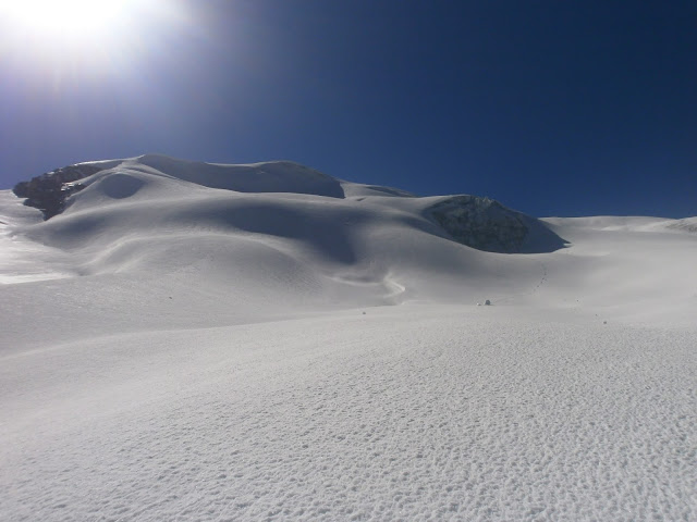
I was glad to find out that the glacier was nowhere near as easy- angled as it looks like from afar. It was not very steep, but I liked it. This is still the first part of the climb, and the highest summit is not in the picture.
Some foreigners ski down Mururata, and it indeed would be super nice for skiing especially in the right conditions. Now the snow was hard, but the surface was quite rough. Still would have been ok for skiing. I didn't see anybody else on the mountain. From 5600 meters I was able to see the distant highest summit, but I turned left a little bit because I wanted to see the other (north to east) side of the mountain that is very steep. The other side could be totally unclimbed since there is no information or mentions on anyone climbing it online or in a guide book. It would be quite difficult to get to the base of the mountain on that side. I took some of the greatest pictures I have ever taken and enjoyed the magnificent views of La Paz, Altiplano, Chacaltaya, Huayna Potosi, Tiquimani, the ocean of clouds over Los Yungas, Illimani, and all other mountains. I could even see for the first time the mountain range called Cordillera Quimsa Cruz to the southeast of Illimani. The highest peak there is 5800 meters high which is pretty high. That area is climbed by very few. It was also interesting to see the other side of Illimani.

The sun was quite warm and high on the mountain and a lot of times the snow gave up just a little bit under my steps. The highest point of the mountain is the right summit.
I was on the summit at 12.00 o'clock after 11,2 kilometers on foot in 4.01 hours moving out of 4 hours 30 minutes since I left the car. Elevation gain was 1650 meters, over a mile. I spent 11 minutes on the summit and then began going down. Where the snow was good, I was able to jog and run down the slopes. It took only 1 hour 7 minutes in total to get out of the glacier, and after that I ran some parts too, but while trying to find an easier route, it turned out a lot harder than the route I had ascended- a very typical result. So, from the glacier it took 1 hour 52 minutes to reach the car when I had hoped for 1 hour. All in all it was a 22,1 kilometers or 13,75 miles long trip car to car in 7 hours 40 minutes including all the stops and everything.


Eka kommentti taisi hävitä bittitaivaaseen. Kivoja huippuja olet käynyt. Itsellä tarkoitus käydä Mururata ja Huayna Potosi tänä vuonna. Asun muuten La Pazissa, joten jos huvittaa vaikka törmätä niin kilauta 69829081
VastaaPoista